Slope protection with an earth retaining system : respectful of natural resources and the landscape
Read now the article of Steve Gruslin, Director of Geotechnics & Engineering Geology department and Domenico Nola, Director of Engineering department appeared in the last edition of EuropeanGeologist magazine. They are presenting their approach in the renovation of the road between Echternach and Berdorf after the heavy rain in 2018.
In order to keep a good ecological balance, the materials excavated on site were reused in the renovation. In addition, the proposed solution blends harmoniously into the landscape.
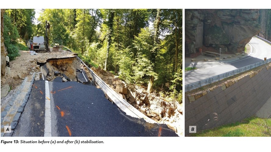
Heavy rains in June 2018 damaged a road between Echternach and Berdorf so severely that it had to be closed. The river along the road below it destroyed the existing stabilisation structures, such as retaining walls and gabion walls, and severely eroded the natural slope covering the underlying Luxembourger Sandstone. Water infiltrated the embankment, causing landslides extending in several places to below the body of the roadway. After clarifying the geological situation and determining the geotechnical parameters of the materials, renovation was carried out using natural materials present on the site, which were used to recreate load-bearing structures reinforced by geogrids and adapted to the landscape in topographically very difficult conditions. From a sustainability standpoint, landslide materials and locally excavated materials were reused in a resource-saving manner.
During the night of 31 May to 1 June 2018, several parts of the Grand Duchy of Luxembourg were severely affected by violent thunderstorms, which were sometimes accompanied by floods. This was particularly the case for the Mullerthal region, nicknamed « Luxembourg’s Little Switzerland », which is a popular tourist and hiking destination. The road linking Echternach to Berdorf and Beaufort (CR364), which runs along the Aesbach Valley on the south side, was particularly affected.
Due to heavy rains, with rainfall of up to 90 litres per square metre, several land slides occurred. In addition, the Aesbach flood caused considerable damage to the embankments and protective structures of the roadway, consisting of retaining walls, gabion walls and backfills. Many buildings were also severely affected by the floods, and several bridges and walkways were completely destroyed. Given the geology and the topography of the area, the occurrence of small landslides is not uncommon in the region, but never with the magnitude of these which occurred due to the bad weather, so the road had to be closed immediately.
The damage that occurred and the corrective measures implemented are described below for two areas in particular, but many other areas required emergency measures to be put into place. In addition to the measures described below, a large number of renovation measures such as retaining supports, installation of drainage systems, etc. were carried out on the entire road, but they are not the subject of this article.
The geotechnical studies and the planning of the measures allowing the rehabilitation of a portion of approximately 1.1 km of the CR364 road were carried out by the design office Géoconseils S.A. on behalf of the “Administration des Ponts & Chaussées du Luxembourg”.
Corrective actions undertaken
In order to find a sustainable solution and to protect the road against future heavy rains, the damaged existing embankment, which already had very steep slopes, was replaced by a steep embankment made of natural materials reinforced by geogrids that fits perfectly into the landscape.
Extensive geotechnical studies and calculations have shown that landslides can reoccur in affected areas if only limited corrective measures are put in place near the surface. To avoid long-term instabilities, it was necessary to excavate the entire body of the slip over the entire width of the roadway and down to the layers of Rhaetian at risk of slipping. The curved path of the Aesbach created additional requirements by limiting the space available for the basis of the reinforced earth construction
From a sustainability standpoint, most of the excavated material could be reused for backfilling in a way that saved resources. In this context, the excavated material, which consisted of stones, boulders, sand and gravel, was prepared on site with a crusher to produce backfill material with a grain size of 0/45 mm, which was temporarily stored on the road outside the damaged area. In this way, about 70% of the required backfill material could be obtained, which also had a positive effect on the ecological balance.
To provide the support structure for the earth retaining system fill sections, the steep slope system TensarTech GreenSlope was chosen, which allows slopes between 45° and 70° to be created. This system chosen for reinforcement is an adaptable, settlement insensitive securing system made up of steel grid elements in the front and horizontally laid geogrids, so that the backfill material results in a composite load-bearing body with a high degree of ductility.
Based on stability calculations using geotechnical software, the inclination of the elements made of steel grid is 70° and the distance between the layers of the horizontal geogrids is 66 cm. The reinforcement consists of expandable, uniaxially stretched, node-rigid and dimensionally stable geogrids in order to ensure optimal nesting of the backfill material and high long-term strength. To ensure good grip and sufficient stability of the backfill vis-à-vis the existing slope, steps were made in the natural land, with a slope of 5° outwards to allow good drainage of infiltration water.
The lengths of the geogrid were adapted to the geometry of the supporting body and to the constraints of the road and the land and were between 5 m and 8 m. In total, around 8,000 m2 of geogrids were installed in this section. Control of the compaction of the backfill material was carried out by means of plate loading tests on each layer.
For protection against erosion, a mat was placed behind the face of the steel grid element which also allows rapid revegetation. As an additional protective measure, blocks of natural rocks were placed at the Aesbach as protection against erosion in the event of flooding.
To take into account the uneven topography of the site, the reinforced earth construction was built to heights of between 3 m and 9 m. In order to obtain a uniform landscape, berms of about 2 m in width were built every 3 m high. Thanks to the combination of the green construction in reinforced earth, the section of road blends harmoniously into the landscape since the end of the works in summer 2019.
Earth retaining system
Similarly to the Zone 1 renovations described above, the entire slip body was excavated, and a geogrid reinforced earth system (Tensar Tech GS System) was implemented.
Here also, material excavated from the slipping zone was treated on site and reused as backfill material. The variable geometry of the valley required an adjustment of the height, which results in different heights of the reinforced earth structure and the creation of 2 m wide berms. The retaining structure therefore fits harmoniously into the landscape.
In addition to the topography of the valley, the highly variable geometry of the rock that outcropped after the excavation of the landslide zone created an additional constraint. In several places, rock points protruded into the retaining structure, similar to those visible above road level at the “Preacher’s Chair”.
The entire slope will be covered in vegetation soon, because the TensarTech GreenSlope system will promote vegetation growth on the surface, helping it to blend in with its surroundings.
Drainage systems
The damage repairs had to take into account the causes of the damage. Here, it was the heavy rains and the water infiltrated into the embankment, associated with a very particular geological and topographical situation, that led to the landslides. It is therefore imperative to collect the water through appropriate drainage systems and discharge it without damage.
Two issues had to be taken into consideration :
- the risk of erosion from the river
- the risk of runoff and infiltration into the backfills
Regarding erosion, it was decided to protect the lower parts with a stone facing to avoid direct contact with water. In addition, riprap was placed in the riverbed to reduce the speed of the stream.
To manage the surface water, drainage has been put in place to prevent water infiltrating into the backfills from softening sensitive geological layers, and also to prevent erosion. A drainage ditch was dug at the foot of the load-bearing structure in order to be able to evacuate surface water which flows through the structure. The berms have a slope of 5% towards the outside.
To drain the water coming from the slope, a drainage layer of at least 30 cm thick of 8/16 mm gravel was installed between the excavation slope and the supporting structure, separated from the existing soil by a geotextile. The water is discharged via a DN 200 drainage system and can be discharged at 2 points through solid pipes under the supporting structure. The water is then diverted to the receiving water via constructed drainage ditches. Fortified drainage and overflow ditches have also been created in other areas where high water flow could be expected during heavy rains.
Conclusion
The roads and the steep slopes of the embankments present in the Mullerthal require special attention due to their topographical characteristics and the resulting demands on stability and drainage conditions. Two examples were used to show how landslides that have occurred can be remedied economically and safely. Reinforced earth constructions are particularly suitable for this because they can be integrated very well into the landscape thanks to their design options. The possibility of reusing the materials excavated on site ensures a good ecological balance. At the end of the work, the green support structures fit harmoniously into the landscape and, at least in these areas, future damage from heavy rains is likely to be avoided.
More informations into the article published in the European Geologist magazine
À propos de L.S.C. Engineering Group
L.S.C. Engineering Group, résultat de la collaboration historique de Luxplan et Simon-Christiansen & Associés, abrite aujourd’hui neuf sociétés au Luxembourg et six sociétés à l’étranger.
Ces dernières associent quotidiennement leur savoir-faire afin de répondre aux exigences du marché dans le domaine de la construction et de l’aménagement du territoire. Les prestations proposées ont pour objectif d’accompagner le client tout au long d’un projet de construction, de rénovation et/ou de transformation.
Avec plus de 44 ans d’histoire, l’engagement et le savoir-faire d’un personnel expérimenté et pluridisciplinaire ont hissé le groupe au niveau des leaders du marché luxembourgeois. Caractérisé par la diversité de ses effectifs, le groupe compte aujourd’hui plus de 300 collaborateurs composés de jeunes talents dynamiques et d’employés expérimentés.