LIST contributes to monitor Mozambique floods with satellite imagery
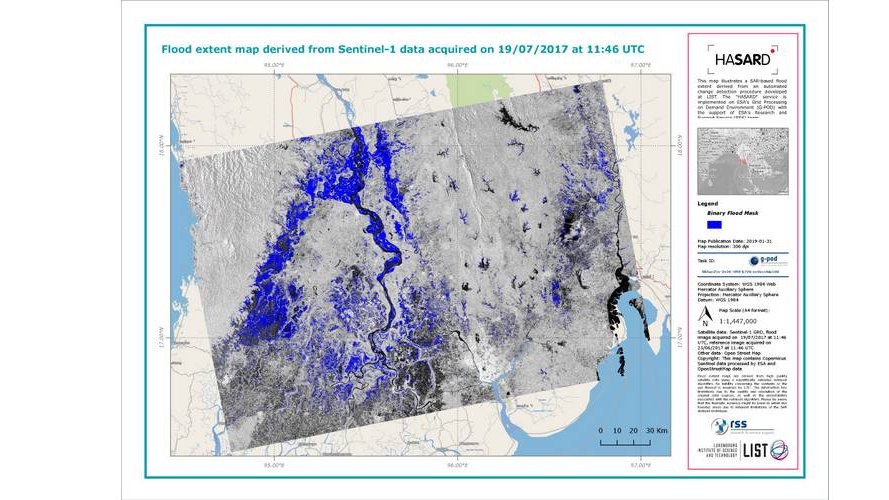
The HASARD® tool, a LIST technology allowing for flood maps to be generated on a global scale using satellite data, has just been upgraded on the European Space Agency’s GPOD platform.
Flood episodes pose a real challenge to authorities and inhabitants alike. In order to enable them to take the most appropriate protection measures, researchers from the Luxembourg Institute of Science and Technology (LIST) have developed HASARD in order to automatically produce, record and disseminate accurate floodwater maps that can be used by as many people as possible. The HASARD® tool is composed of an algorithm and a dedicated software. Last year LIST made it available to the international research and disaster management community through the Grid Processing on Demand (GPOD) platform of the European Space Agency (ESA). The tool – open to all and requiring an online account application – is being continuously improved through new versions.
Research community and disaster managers : generate your own maps with Hasard®
The HASARD® tool offers scientists and disaster managers from around the globe the ability to generate flood maps from satellite images, in virtually any region in the world. The HASARD® tool, which can easily differentiate flooded from non-flooded terrain, is of real benefit to the authorities responsible for managing floods : any scientist or disaster manager can produce their own flood maps for a specific area and predefined periods of times.
After several months, a newer version of the tool has just been integrated in collaboration with ESA. It is now easier for users to navigate and use the tool, thanks to both improved ergonomics and user experience. In addition, the algorithm now offers a better classification and many additional mapping options. LIST researchers specialized in remote sensing and natural resources modeling are already working on the next version.. They use flood episodes across the globe to test the limits of their tools and highlight areas of improvements. This is all the more important since HASARD is dealing with a wide variety of floods as it can be used at any time of day by worldwide users.
Mozambique disaster as case study
On March 2019, Mozambique was affected by severe floods caused by the Tropical Cyclone Idai which is regarded as one of the worst tropical cyclones on record to affect Africa and the Southern Hemisphere as a whole. The flood maps generated by LIST with the HASARD tool have been employed to map the area under water for different organizations managing the response to this event, such as the NASA Earth Science Disasters Program, the World Food Program (WFP) of the United Nations and the Global Flood Partnership. The LIST software applied to map floods and their impacts in Mozambique represents a novelty. It now takes advantage of the enhanced imaging features provided by the latest European Copernicus satellites to better identify urban areas impacted by an event. This new version of the mapping software is the result of the latest activities of LIST researchers in the frame of MOSQUITO, a multi-annual project funded by National Research Fund of Luxembourg through its CORE program.
“For the first time, we could test our new algorithm in an operational context” said Marco Chini, the principal investigator of MOSQUITO. “We received very positive feedback from the users of our new data. The capacity to monitor floodwater in built up areas with radar satellites, in this case within the city of Beira, the fourth largest in the country, is considered by many as a major advance in the field”.
Cartography and satellite technologies : challenges still remain
At the moment, LIST pursues its work on the development of tools allowing to efficiently process satellite images for flood hazard monitoring and prevention on a global scale. Recently, LIST and ESA have launched a new research project entitled e-Drift - “Satellites Earth-Observation-based solutions to support Disaster RIsk Financing and Transfer in South-East Asia”. The project partners intend to develop a fully automated tool - based on HASARD ® - that could generate different flood risk maps, with no human intervention, as soon as a flood disaster occurs.
“E-Drift will enable the creation of new near-real-time flood monitoring capacity in South-East Asia, giving accurate information on the extent of flooding, as well as the number of affected persons in risk prone areas of Myanmar, Vietnam and Cambodia. In particular, it will provide reliable and useful input data to insurance companies, allowing them to improve their emergency response”, said Patrick Matgen, responsible for the Earth Observation component of the project.
Find more information online about MOSQUITO and EDRIFT
The Luxembourg Institute of Science and Technology (LIST) Press release