Is flooding a real threat for us ?
Maybe you remember the persistent rainfall in July – reports of flooding have been rife. With the ground already saturated, flooding were back this year in Luxembourg and impacting the life of everyone, especially those who suffer from material damages. On the one side volumes of rain fallen during 30 minutes up to 24 hours in July were highest scores since 1947, on the other side the months of August and September were really poor in rain : just one third of the thirty year average (1981-2010). Just a spike or does it mean more ?
Flooding are natural phenomena. The natural variation of water levels is part of the feature of rivers. It is the basis for river flow dynamics and the development of a typical floodplain profile. Extreme flooding occur when intensive precipitation falls on soils, which are already saturated due to former precipitation or which are frozen and can thus not absorb any water. Besides the global warming, floods are also stressed by bad agricultural practices, the “artificialisation” of the wet lands, the intensification of the agriculture, the extending urbanisation, or with bad agricultural practices that deplete grounds resulting in a reduction of infiltration of the water.
What are the predictions ? According to different reports scientists tell us that the frequency of severe flooding across Europe is set to double by 2050 and over the same period there could be a nearly fivefold increase in the annual economic losses resulting from floods, a study has found. Climate change and an increase in rainfall will account for about a third of the losses by mid-century, with the rest of the increase being due to more properties and infrastructure falling within flood risk areas. What does that mean for Luxembourg and what are the risks of the impact of frequent flooding ?
Based on preliminary studies OECD’s profile of climate change impacts on water systems for Luxembourg tells that the annual totals of precipitation would be relatively stable up to 2100. However, a substantial redistribution of seasonal precipitation totals could be expected in the second half of the century, with a decrease in summer rainfall and an increase in winter precipitation. In winter, increase in rainfall from 0 to 25% by 2050 with increasing discharges. In summer, decrease in rainfall of 5 to 25% with reduced run-off by 2050. The studies predicted a deterioration of water quality due to intensification of rainfalls (increasing erosions, rapid infiltration towards groundwater) and a shift in the main recharge period of groundwater. Furthermore, changes in the water cycle could increase public health risks related to water quality and water scarcity. (http://www.oecd.org/env/cc/). Therefore, the variations of precipitation have a negative impact on the biodiversity : the ecological niche model, used by the scientists, has permitted predicting that for many ecosystems, the capacity of regeneration facing climate change and the disturbances which it causes will be extremely weak. So impacting on the agricultural yield and thus on the economic growth. Damages include also physical damages on buildings, infrastructures, cultural heritage, the loss of life, sanitary effects and the disturbance of the transportation and railway networks.
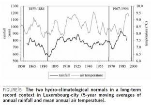
Modelling the past to prevent risks in the future ! In the nineties Luxembourg has been subject to extreme flooding for several times. Since then, a group of experts in hydrology did a lot of research work to investigate the causes that might have generated these events. They looked closer to historical hydro-climatological observation series to find coherent hydrological patterns and found out that there has been a significant increase of winter rainfall and a decrease of summer rainfall between the end of the 1950s and the beginning of the 1990s. Furthermore, the data show that rainfall totals were more important during the second half of the twentieth century. This may be linked to the influence of an increased of humid airflows from the Atlantic. The researchers set up a monitoring network in the country to follow the flood generating processes. They found out that the annual rainfall totals of the recent past are above the annual rainfall totals written in historical series. Hydrological impacts of climate change at catchment scale : A case study in the Grand-Duchy of Luxembourg. (Hydrological impacts of climate change at catchment scale : A case study in the Grand-Duchy of Luxembourg)
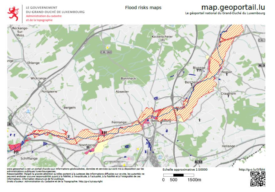
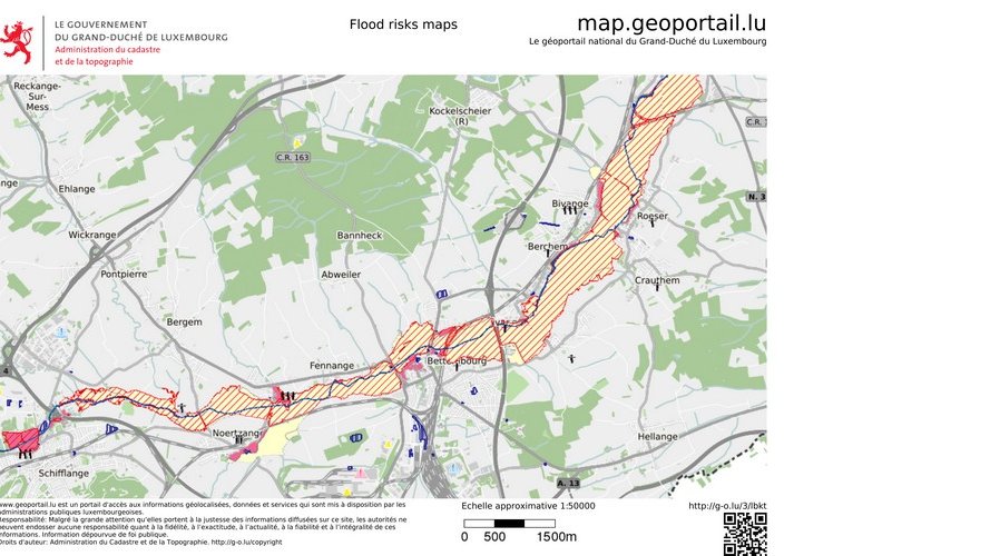
Various human interferences have clearly altered the river regime creating spots that are predestined to be over flooded if no countermeasures are taken. According to European legislation member states must establish a framework for assessing, mapping and planning for the reduction of the risk of floods in Europe. Therefore, the national water agency has produced maps that identify areas prone to significant flood risks and indicate scenarios (based on high, medium or low probability) of a flood occurring there. Those maps are free for everyone under www.eau.geoportail.lu and should be consulted by everyone who wants to buy in the future land.
Sustainability : In Luxembourg large urban projects are designed to incorporate sustainability concepts. A prominent example is the plateau of Kirchberg, a 365-hectare urban project, a so called office town. Twenty kilometres southwards takes the Belval urban renewal project place. This 120-hectare site is planned for 5,000 inhabitants and 20,000 employees. Luxembourg’s rural developments prove that large urban projects are certainly not limited to major metropolitan centres. And large-scale urbanism will be expected by sophisticated urbanites seeking the trappings of modern city living. All the investment in urbanisation projects will stimulate the economic growth and attract more people to settle down in Luxembourg. The demographic projections estimate that the total population in Luxembourg would reach 1 million inhabitants from 2046 onwards, namely double the current population (http://www.fondation-idea.lu/2015/07/08/the-one-million-luxembourg-a-global-analysis-is-needed/).
This growing resident population generates problems on spatial planning as space is a limited source in Luxembourg. Day in, day out, land is asphalted and further green hectares are classified future urban zones. Every year the residential surface is increased by 1.5%. But the upgrading of mobility infrastructure and the extension of economic development zones also consume land – and this land is missing to soak up rain and delay and reduce flooding. It is therefore difficult to imagine that the actions described in flooding management plan as the preservation of natural river morphology and the reestablishment of river morphology and a natural river dynamic will be makeable and effective. In this context it is essential to prevent the deterioration of the morphology conditions of the bodies of surface water. The image below shows that the riparian zone’s structures of many bodies of surface water are in bad state.
The vision of Luxembourg 4.0 is far from eco-friendly.
Communiqué par Waasser Consulting